


ROAD MAP
Information on the path taken by Aimé-Adrien Taunay
The road taken by Aimé-Adrien Taunay, between June 18th and July 3rd 1824, connecting the capital to Morro Queimado, where the Swiss colony of Nova Friburgo was established, was very well known and traveled. The region had been explored since the 17th century through the establishment of small and medium properties, dedicated to the production of sugar, cachaça and supplies. There was also the exploitation of wood (for small boats widely used in the rivers of the area and in the transport of food in the Guanabara Bay), as well as fishing and animal breeding. The territory was inhabited by indigenous groups called Puris and Coroados, many of whom were villagers, catechized by religious orders (such as the Carmelites and Jesuits) who held vast sesmarias.
After the coming of the Court, in 1808, D. João’s government encouraged the expansion of the agricultural borders of the captaincy of Rio de Janeiro towards the Paraíba Valley and the mountainous region. There was a deliberate policy of distributing sesmarias in areas occupied by religious orders and indigenous groups, which resulted in armed confrontations and the incorporation of indigenous people into the economy as labor. The establishment of the Swiss colony partly responds to those demands for supplies for the city of Rio de Janeiro. Actually, lands in Cantagalo and Nova Friburgo were also coveted by local and foreign farmers for coffee plantation.
In this context, it is likely that Aimé-Adrien Taunay’s trip was financed by French traders and entrepreneurs and by the French diplomatic representative, the Count of Gestas, established in Rio de Janeiro since the transfer of the Portuguese court. Everything indicates that the purpose was to deepen their knowledge about farms and of viable production to be implemented by French investors.
Instructions issued by Count of Gestas, that Chateaubriand (Minister of Foreign Affairs of France at the time) received between 1824 and 1825, during the negotiations for the treaty that recognized the Brazilian Independence, aimed at expanding the influence of France against Great Britain which was also seeking commercial advantages in imports, especially sugar and coffee, since Brazil competed in the international market with the French production from the Caribbean.
The farm owned by the Count of Gestas in Tijuca was neighboring that of the Taunay family. The place was a meeting point for French dealers and artists based in Rio de Janeiro, where dinners and receptions took place. It was even attended by Dom Pedro and Dona Leopoldina, as well as by other Court politicians.
| Date/Site | Report |
|---|---|
|
Date: Site: |
"Friday, June 18th, 1824. After having dinner at the Count of Gestas' house, I embarked to Praia Grande with Louis, a Count of Gestas' Negro called Martin, and two mules". p. 4. "[...] disembark at last around 2 o'clock. I arrived at C. de Gestas' home. Dinner [...]" p. 63. |
|
Date: Site: |
1.1's alternative location, as the French Consulate was one of the Consul's addresses as well. |
|
Date: Site: |
"Rest in Praia Grande at the Inn." p. 4. "Friday Jul[y] 3rd De[p]arted with the stars lunch in Praia Grande, [at] a tavern." p. 63. |
|
Date: Site: |
"We sighted several boats carrying a cavalry from Santa Cruz to Praia Grande [...]." p. 4. |
|
Date: Site: |
"The sun rose behind the small church of St. Anna which stood out on the very fertile shore of the sea in the red hinterland." p. 5. |
|
Date: Site: |
"Portão Vermelho" [Red Gate]. p. 2. "St. Anna's church that stood out on the very fertile edge of the sea in the red hinterland". p. 5. |
|
Date: Site: |
" [...] Passing by São Gonçalvo, a very populated village the church lunch in Venda Grande [...]." p.5. "I set off again on my way to Venda Grande, where I stopped and slept so as not to reach Praia Grande at night where I predicted the boats would be impossible to obtain p. 60". |
|
Date: Site: |
"Arrival at 3 o'clock in São João de Taboraí. lodging in a kind of tavern further on from the church. p. 6. "Thursday July 2nd crossing some mildly high virgin woods in the plains. resume São João road, lunch in São João." p. 60. |
|
Date: Site: |
"Tapa - Coral [Sap] and Cacarabou (Bridge of) [...]." p. 2. |
|
Date: Site: |
"Caminho de Macucu ´[Macucu Road] Ponte Pinheiro [Pinheiro Bridge] Tavern. Cacarabu bridge covered with tile[s]<.> long [...]". p. 8. |
|
Date: Site: |
"we stopped at the Venda do Colégio, located between the [b]ri[ck]yard of the Carmelite Brothers [...] p. 8. "Arrival at two o'clock at Venda do Colégio[...]". p. 59. |
|
Date: Site: |
"Arrival around 4 o'clocl in Santa Anna. lodging at the Inn. p. 12. "Pass by in front of the Santana church , just as mass was about to begin." p. 59. |
|
Date: Site: |
Lunch at Colonel Ferreira's farm. p. 14. "I slept in Colonel Ferreira's mill [...]." p. 57. |
|
Date: Site: |
Venda do Registro debaixo [Tavern of Registro debaixo] held by a Swiss. p. 16. "[...] noon to 2 food and rest at the tavern of the Swiss from Registro debaixo." p. 57. |
|
Date: Site: |
"Tuesday, June 22nd. We cruised the horrible roads and go down high stony that go up to the plateau whose [bottom] is Morro-Queimado." p. 16. |
|
Date: Site: |
Arrived at Ba[lm]an's house [...]. p. 16; "finally returned to Balman's house to spend the night there." p. 55. |
|
Date: Site: |
"I went to visit Mr. Régami[er] kind of empirical doctor. Dinner at his house. p. 17. "I went back to dinner at Mr. Régamier's house." p. 18. "I went to Mr. Régamier's house to ask him for seeds again for Mrs. Masson [...]." p. 54. |
|
Date: Site: |
"I then went out to hunt along the settlers' path [caminho dos colonos] a quarter mile from there [...]. p. 17. |
|
Date: Site: |
"Wednesday 23rd of June. Visit to Mr. Quebremont in the 2nd village." p.17. |
|
Date: Site: |
"[...] I went to the house of the parish priest Mr. Joyet who was at his farm [...]." p. 17. |
|
Date: Site: |
"[...] and at doctor Mr. Bazel's home who had gone to Rio de Janeiro." p. 17. |
|
Date: Site: |
"I then went to Lapeyre's house." p. 17. |
|
Date: Site: |
"Leaving him I went to Mr. T[air]in half a league from the farm." p. 18. |
|
Date: Site: |
"[...] German pastor, [...] he took me to his house at night." p. 18. |
|
Date: Site: |
"Friday June 2[5]. Leaving for Macaé through caminho dos colonos". p. 19. "Morro [Hills] [...] Cantos Macaé [...]." p. 39. "In Macaé not very pretty coffee big and white moist [...]." p. 42. |
|
Date: Site: |
"Initially lost, when going back I met an old German settler, whom I followed, and without whom he left me in the 113th number on the settlers' plot of land [...]." p. 20. |
|
Date: Site: |
"Finally, going back to the open plain we saw the fires of a house I entered and called over the palisades around it; and Mr. Matilyn [...]." p. 20; "[...] I was carrying a jacutinga bird that Mr. Leguier had given me and that I wanted to bring to Mr. Matelin [...]." p. 22. " Monday 29th June. I set out again to meet Louis and the mules; after saying goodbye to Mr. Matilin [...]." p. 53. |
|
Date: Site: |
"Sunday, June 27. I went after lunch to Mr. Tribouillet's home, a nearby neighbor, to whom I delivered two letters from Mr. G. [...]. p. 21. "I went back to Mr. Tribouillet's house [...]." p. 22. |
|
Date: Site: |
"[...] at Mr. Légu[ie]r.'s house the weather was of horrible sadness [...]." p. 22. |
|
Date: Site: |
"Santa Luzia Desert [...]." p. 37. |
|
Date: Site: |
"60 leagues. Roman Catholic mission[s] [...] Father Thomas Aldeia da Pedra [Stone Village]. p. 38. |
|
Date: Site: |
"a cafe[...ne] [......] of Mr. Lorenzo [u] f[oot] of Rochedo do Cônego. [river] Cônego B[angal] Santo Antonio [...]." p. 41. |
|
Date: Site: |
"The [Canta] [Gallo] coffee cane sugar hard to obtain arable land [...]." p. 41. |
|
Date: Site: |
Baixo Macaé tout chap[...] coffee after 3 years a 1/2 pound of coffee. p. 42. |
|
Date: Site: |
"When I arrived at Burnier's house." p. 53. |
|
Date: Site: |
"I went to Bardy's house where I bought alfalfa seeds [...]." p. 55. |
|
Date: Site: |
"En[s]ign Constantino Barboza's farm em Sepetiba [...]." p. 59. |
|
Date: Site: |
"Meeting Felix at night in the chair of Mde Mafon [...]che in [Teijuka]." p. 64. |
|
Date: Site: |
"Janua[ry] 9, 1825 pleasant night sp[ent] on a cruise (b2l) [by] myself [..] along the hills of Liv[ra]mento l. [….] p[...] [.]odos the [...]piches de Saude (where the negores are hung) of order, valongo. [..] [A….erte] of Livramento enchanting [panorama]. [...]." p. 31. |
|
Date: Site: |
"February 22nd, 1825. When I was behind [C..........] de São Bento [St. Benedict] in the setting sun, reading the ode of Lago Lamartine [...]" p. 92. |
Images associated with the route
| Image | Report |
|---|---|
 enlarge
|
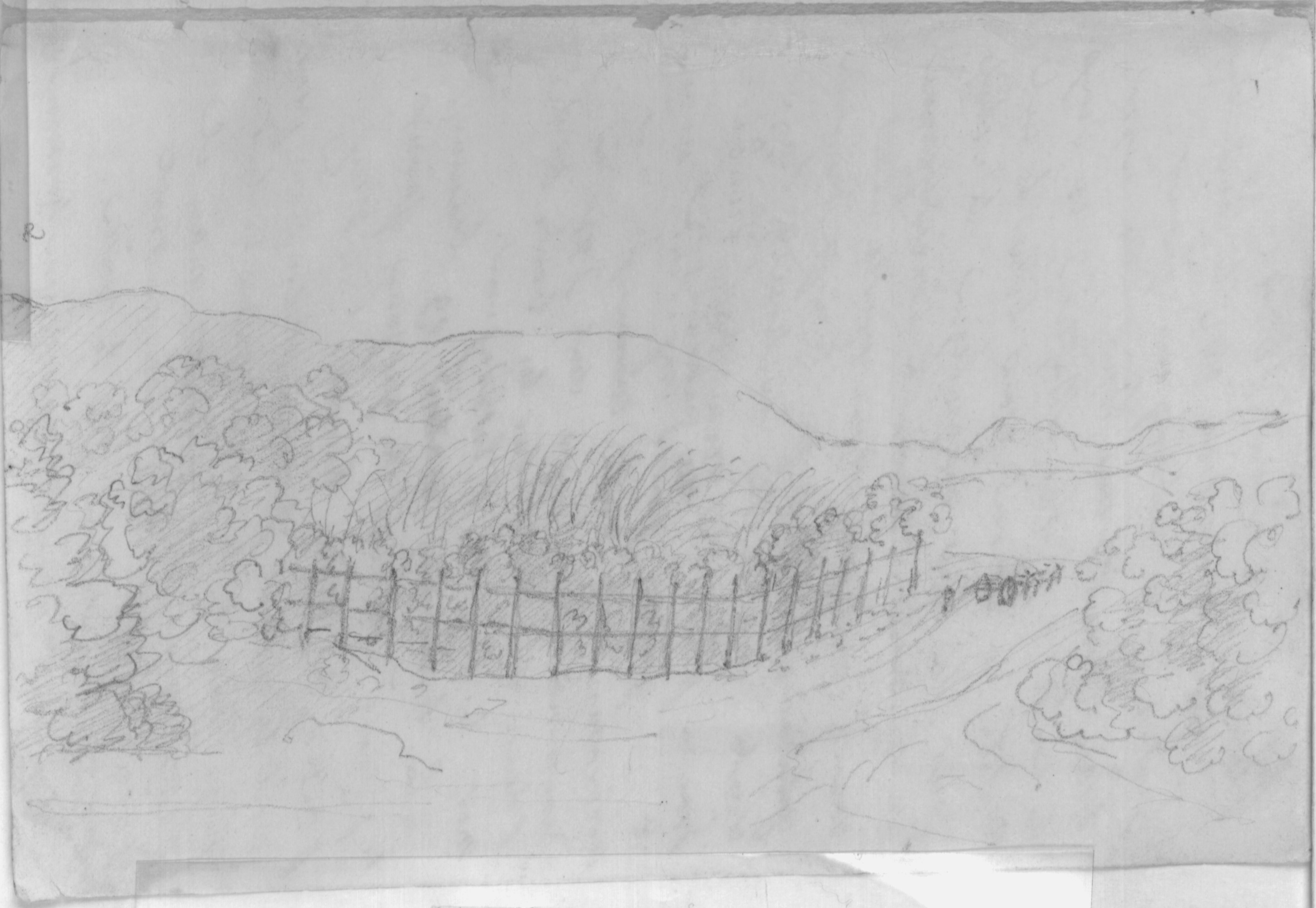
Drawing associated to the road between Praia Grande and São Gonçalo. See numbers 2, 4, 5 and 6. Sketch of a path flanked by fence, plants and an animal-drawn vehicle being guided by a person standing next to it; at the bottom of the apparent high ground. |
![Picturesque views of the bay through the living fences, the trees beyond a species of crowned pastures, as you advance, through the tips of [organs]. House in front of which extends a line of banana trees beyond a large savannah, and on the coast a long line of virgin forest p. 5. Page of Aimé-Adrien Taunay's manuscript.
Collection of Museu Paulista / Universidade de São Paulo (São Paulo)](/images/roteiro-dos-caminhos/f4f_p7_d/IRR.jpg) enlarge
enlarge
|
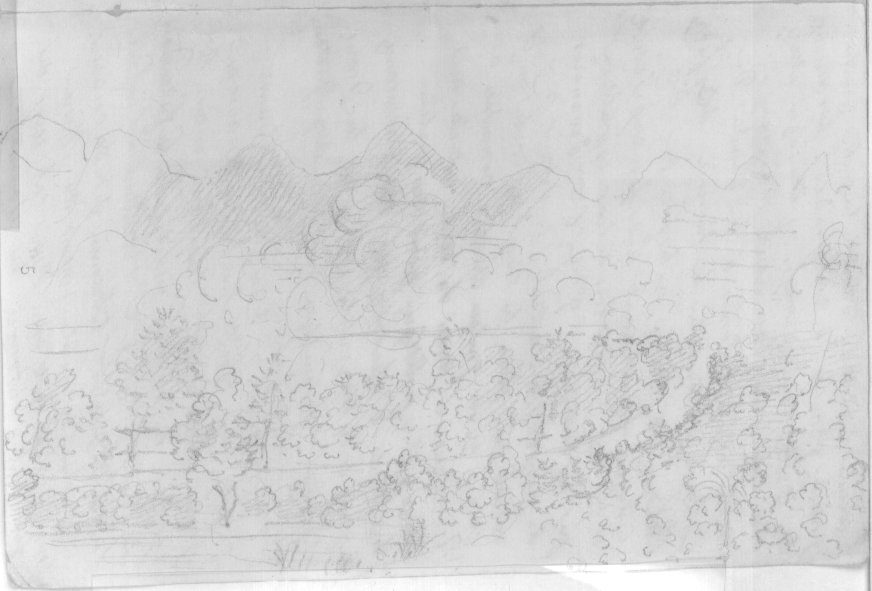
Drawing associated to the road between Santa Anna and São Gonçalo. See numbers 4, 5 and 6. Picturesque views of the bay through the living fences, the trees beyond a species of crowned pastures, as you advance, through the tips of [organs]. House in front of which extends a line of banana trees beyond a large savannah, and on the coast a long line of virgin forest p. 5. |
 enlarge
|
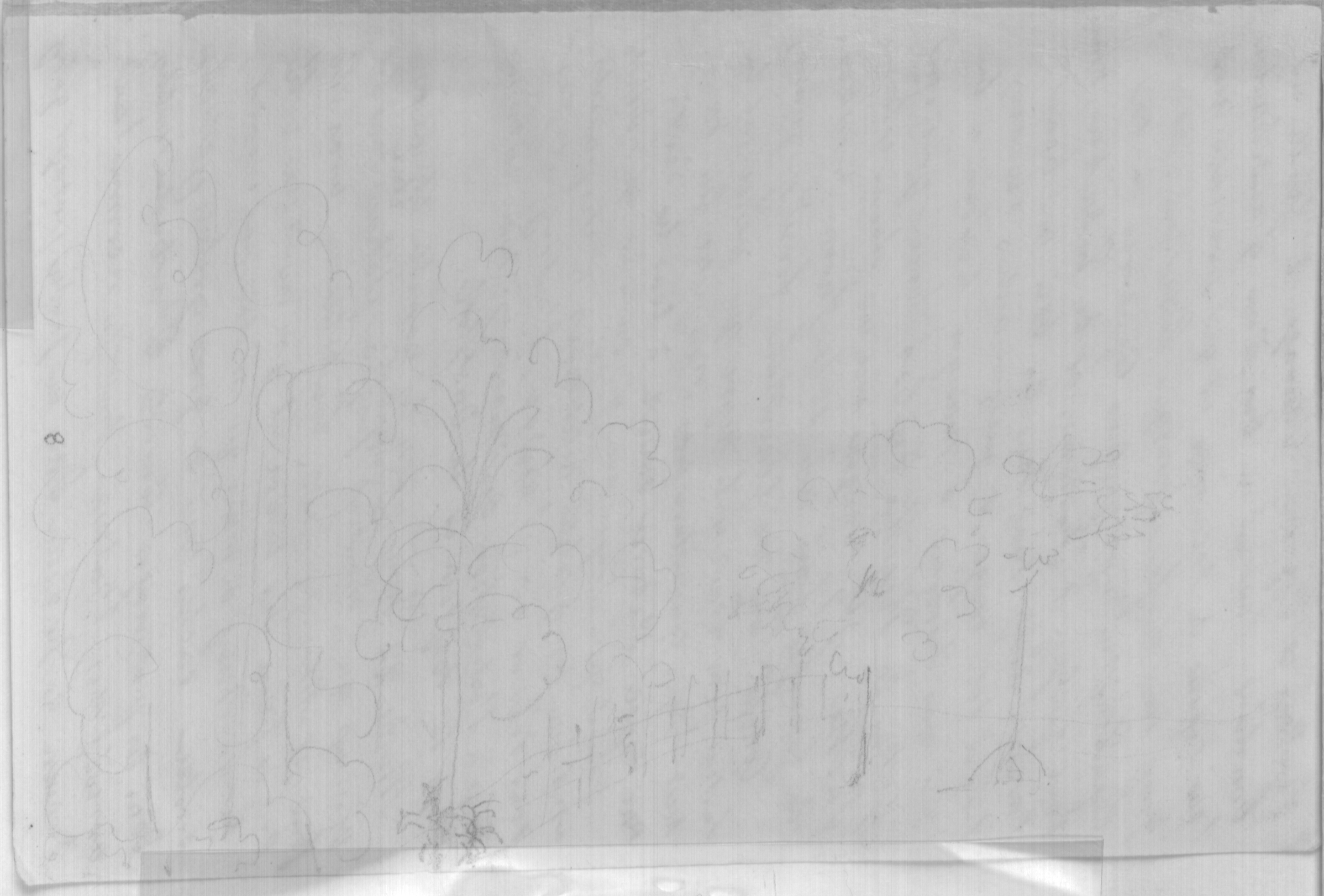
Drawing associated to the road between São João de Itaboraí and Ponte Pinheiro. See numbers 7 and 8. Sketch of landscape highlighting the floristic, water and geological elements. |
 enlarge
|
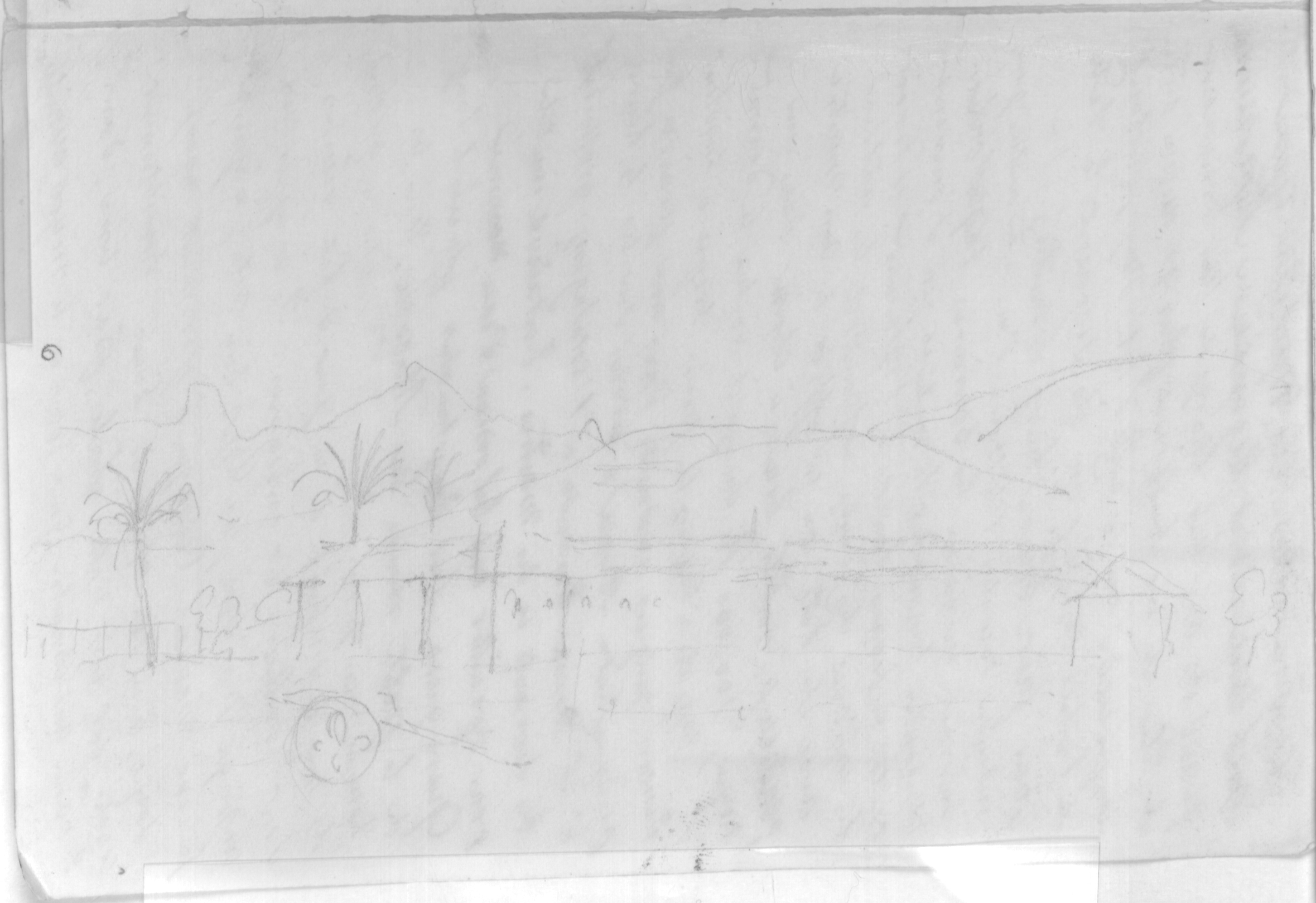
Drawing associated to Venda do Colégio [Tavern of the College]. See number 9. Construction outline and mountainous relief background. |
![[...] Colonel Ferreira's farm. well-established mill with a good water wheel, and a wooden aqueduct to bring water. the mills turned. p. 14. Page of Aimé-Adrien Taunay's manuscript.
Collection of Museu Paulista / Universidade de São Paulo (São Paulo)](/images/roteiro-dos-caminhos/f7f_p13_d/IRR.jpg) enlarge
enlarge
|
Drawing associated to the Engenho do Coronel Ferreira [Coronel Ferreira's Mill]. See number 11. [...] Colonel Ferreira's farm. well-established mill with a good water wheel, and a wooden aqueduct to bring water. the mills turned. p. 14. |
 enlarge
|
Drawing associated to the road between Engenho do Coronel Ferreira [Coronel Ferreira's Mill] and Registro Debaixo. See numbers 11 and 12. Sketch of relief profile and floristic composition with character mounted a mule. |
